 Katrina Update #2Katrina Update #2
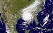
The fabled doomsday scenario continues to play out. At 8AM this morning Central time, Katrina had a barometric pressure of 908mb. As a comparison, at landfall Andrew (1992) was 922mb, Camille (1969) was 909. Only the Labor Day hurricane of 1935 packed stronger winds. It was 892mb at landfall, hitting the keys, skirting the coast and hitting the eastern Panhandle of Florida.
Janis and Jarret are in Cary's car heading out of town. Cary's girlfriend and her brother are in the brother's car traveling with them. They left our house about 5AM. At 8AM they had made it about 5 miles to Metairie Road. They are heading to Janis' cousin Connie's house in Texas.
Adam, his girlfriend and his girlfriend's mom are headed east towards Florida (the mother lives in Slidell, which is east of New Orleans.
At this point, the eye is expected to turn to the North and go east of New Orleans. This would take it in pretty much the same landfall path as Camille. But this is a bigger storm. If this holds true, New Orleans may escape "catastrophic" damage, but it will still have devastating damage. We have many friends who elected to stay in New Orleans, either because they didn't have transportation or because they wouldn't.
They are expecting a 20 - 25 foot storm surge in New Orleans, which would literally close the city for months. I am hoping the storm moves far enough to the east for New Orleans to escape this.
Here is the forecast for the next 36 hours, with wind predictions you aren't likely to see for decades in New Orleans.
Monday
Numerous showers and isolated thunderstorms in the morning...then widespread showers and isolated thunderstorms in the afternoon. Hurricane force winds. Highs in the upper 80s. Northeast winds 55 to 75 mph becoming east and decreasing to 50 to 60 mph with gusts to around 95 mph in the afternoon. Chance of showers and thunderstorms 90 percent.
Monday Night
Mostly cloudy with numerous showers and isolated thunderstorms in the evening...then partly cloudy with scattered showers after midnight. Strong winds. Lows in the upper 70s. Southwest winds 25 to 55 mph decreasing to 15 to 25 mph after midnight. Chance of showers and thunderstorms 60 percent.
If you have been watching the weather channel, you may have seen a statistic that says New Orleans gets a major hurricane every 9 years. This is a Cat 3 or higher making landfall within 40 miles of the city. It is that "40 miles" figure that is significant. Most of the storms that meet that criteria (Georges, in particular, in 1995) hit on the edge of that 40 miles and usually over to the east, which means New Orleans only experiences tropical storm force winds. New Orleans has never had a direct hit of a Cat 3 or higher.
The Superdome has been opened as a "special needs" shelter and shelter or last resort. It was built to withstand sustained winds of up to 200mph, but has never been tested, of course.
I'll update you again later today with information on where Janis and Adam have landed.
HOME | UPDATES | DONATE | GALLERIES | PEOPLE | STORIES | LESSONS | LINKS